Woburn | |
|---|---|
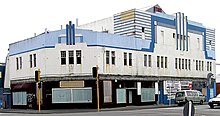
 Hutt Railway Workshops pattern shop in 1930 | |
 | |
| Coordinates: 41°13′S 174°54′E / 41.217°S 174.900°E | |
| Country | New Zealand |
| City | Lower Hutt |
| Local authority | Hutt City Council |
| Electoral ward | Central / Harbour |
| Established | 1840s |
| Area | |
| • Land | 0.62 ha (1.53 acres) |
| Population (June 2024)[2] | |
• Total | 1,850 |
| Train stations | Woburn Railway Station |
| Lower Hutt CBD | Waterloo | |
|
|
Waiwhetū | |
| Ava | Moera |

Woburn is a suburb of Lower Hutt, Wellington situated at the bottom of the North Island of New Zealand.
Henry Petre farmed the area in the 1840s and named the area after the Duke of Bedford's estate, Woburn Abbey. Petre's farm was later taken over by Daniel and Harriet Riddiford, whose descendants built a large home there, with the land being gradually subdivided.[3] Riddiford Street in Lower Hutt commemorates them.
- ^ Cite error: The named reference
Areawas invoked but never defined (see the help page). - ^ "Aotearoa Data Explorer". Statistics New Zealand. Retrieved 26 October 2024.
- ^ Te Ara: The Encyclopedia of New Zealand - Hutt Valley - central and west Retrieved: 10 January 2009