Woking Borough of Woking | |
|---|---|
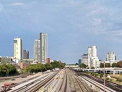
 Woking town centre from the west | |
| Motto(s): | |
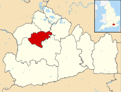
 The Borough of Woking in Surrey | |
| Coordinates: 51°19′13″N 00°33′24″W / 51.32028°N 0.55667°W | |
| Sovereign state | United Kingdom |
| Constituent country | England |
| Region | South East England |
| Non-metropolitan county | Surrey |
| Status | Non-metropolitan district |
| Admin HQ | Woking |
| Incorporated | 1 April 1974 |
| Government | |
| • Type | Non-metropolitan district council |
| • Body | Woking Borough Council |
| • Leadership | Leader & Cabinet |
| • MPs | Will Forster (Liberal Democrats) |
| Area | |
• Total | 24.6 sq mi (63.6 km2) |
| • Rank | 232nd (of 296) |
| Population (2021)[2] | |
• Total | 103,900 (estimated) |
| • Rank | 228th (of 296) |
| Ethnicity (2021) | |
| • Ethnic groups | |
| Religion (2021) | |
| • Religion | List
|
| Time zone | UTC0 (GMT) |
| • Summer (DST) | UTC+1 (BST) |
| ONS code | 43UM (ONS) E07000217 (GSS) |
| OS grid reference | TQ0040358550 |
| Website | www |
Woking (/ˈwoʊkɪŋ/ WOH-king) is a town and borough in northwest Surrey, England, around 23 mi (36 km) from central London. It appears in Domesday Book as Wochinges, and its name probably derives from that of a Saxon landowner. The earliest evidence of human activity is from the Paleolithic, but the low fertility of the sandy local soils meant that the area was the least populated part of the county in 1086. Between the mid-17th and mid-19th centuries, new transport links were constructed, including the Wey Navigation, Basingstoke Canal and London to Southampton railway line. The modern town was established in the mid-1860s, as the London Necropolis Company began to sell surplus land surrounding the railway station for development.
Modern local government in Woking began with the creation of the Woking Local Board in 1893, which became Woking Urban District Council (UDC) in 1894. The urban district was significantly enlarged in 1907 when it took in the parish of Horsell, and again in 1933 when it took in the parishes of Byfleet and Pyrford. The UDC was granted a coat of arms in 1930 and Woking gained borough status in the 1974 reorganisation of local government. In 2022, a total of 30 elected representatives serves on the council, each with a term length of four years.
The Borough of Woking covers 64 km2 (25 sq mi) and had a population of 103,900 in 2021.[2] The main urban centre stretches from Knaphill in the west to Byfleet in the east, but the satellite villages of Brookwood, Mayford, Pyrford and Old Woking retain strong individual identities. Around 60% of the borough is protected by the Metropolitan Green Belt, which severely limits the potential for further housebuilding. Recent developments have included the construction of two residential tower blocks in the town centre and the conversion of former industrial buildings to apartments. There are six Sites of Special Scientific Interest within the borough boundaries, of which three form part of the Thames Basin Heaths Special Protection Area.
Almost the entire town centre dates from the 20th and 21st centuries. Elsewhere in the borough, there are several historic buildings, including the ruins of Woking Palace, a royal residence of Henry VII and Henry VIII. Parts of St Peter's Church in Old Woking date from the reign of William I and Sutton Place, built for Richard Weston c. 1525, is one of the earliest unfortified houses in England. The Shah Jahan Mosque, constructed in 1889, was the first purpose-built Muslim place of worship in the UK. There are numerous works of public art in the town centre, including a statue of the author, H. G. Wells, who wrote The War of the Worlds while living in Maybury Road. Much of the novel is set in the Woking area.
- ^ "Coat of arms". Woking Borough Council. 4 March 2013. Retrieved 7 August 2022.
- ^ a b "How the population changed in Woking, Census 2021 – ONS". www.ons.gov.uk. Retrieved 13 November 2022.
- ^ a b UK Census (2021). "2021 Census Area Profile – Woking Local Authority (E07000217)". Nomis. Office for National Statistics. Retrieved 5 January 2024.