| Wolf Creek Dam | |
|---|---|
 | |
| Location | Russell County, Kentucky |
| Coordinates | 36°52′06″N 85°08′51″W / 36.8683°N 85.1475°W |
| Construction began | 1941 |
| Opening date | 1951 |
| Operator(s) | U.S. Army Corps of Engineers |
| Dam and spillways | |
| Impounds | Cumberland River |
| Height | 258 ft (79 m)[1] |
| Length | 5,736 ft (1,748 m)[1] |
| Dam volume | 11,396,500 cu yd (8,713,200 m3)[1] |
| Reservoir | |
| Creates | Lake Cumberland |
| Total capacity | 6,089,000 acre⋅ft (7,511,000 dam3)[1] |
| Catchment area | 5,789 sq mi (14,990 km2)[1] |
| Surface area | 50,250 acres (20,340 ha)[1] |
| Power Station | |
| Turbines | 6x 45.0 MW |
| Installed capacity | 270 MW |
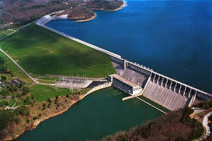
The Wolf Creek Dam is a multi-purpose dam on the Cumberland River in the western part of Russell County, Kentucky, United States. The dam serves at once four distinct purposes: it generates hydroelectricity; it regulates and limits flooding; it releases stored water to permit year-round navigation on the Cumberland River; and it creates Lake Cumberland for recreation, the largest man-made lake by volume east of the Mississippi river. The Lake has become a popular tourist attraction.U.S. Route 127 runs across the top of the dam but is being relocated downstream.
Electricity from the dam is marketed by the Southeastern Power Administration.[2]
- ^ a b c d e f "Wolf Creek Dam". National Performance of Dams Program, National Inventory of Dams. Stanford University. Retrieved 2012-10-10.
- ^ "Generation – Southeastern Power Administration". Energy.gov. Retrieved 2023-03-20.
