Woodsville, New Hampshire | |
|---|---|
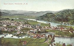
 Bird's-eye view in 1908 | |
| Coordinates: 44°9′08″N 72°2′13″W / 44.15222°N 72.03694°W | |
| Country | United States |
| State | New Hampshire |
| County | Grafton |
| Town | Haverhill |
| Area | |
• Total | 1.88 sq mi (4.86 km2) |
| • Land | 1.85 sq mi (4.79 km2) |
| • Water | 0.03 sq mi (0.07 km2) |
| Elevation | 456 ft (139 m) |
| Population (2020) | |
• Total | 1,431 |
| • Density | 773.51/sq mi (298.68/km2) |
| Time zone | UTC-5 (Eastern (EST)) |
| • Summer (DST) | UTC-4 (EDT) |
| ZIP code | 03785 |
| Area code | 603 |
| FIPS code | 33-87140 |
| GNIS feature ID | 0870998 |
Woodsville is a census-designated place (CDP) and the largest village in the town of Haverhill in Grafton County, New Hampshire, United States, along the Connecticut River at the mouth of the Ammonoosuc River. The population was 1,431 at the 2020 census.[2] Although North Haverhill is now the county seat of Grafton County,[3] the village of Woodsville has traditionally been considered the county seat, as the county courthouse was originally located there. The county buildings are now located halfway between Woodsville and the village of North Haverhill to the south.
- ^ "ArcGIS REST Services Directory". United States Census Bureau. Retrieved September 20, 2022.
- ^ "Woodsville CDP, New Hampshire: 2020 DEC Redistricting Data (PL 94-171)". U.S. Census Bureau. Retrieved December 1, 2021.
- ^ "Find a County". National Association of Counties. Retrieved June 7, 2011.

