| Woomera Village South Australia | |||||||||
|---|---|---|---|---|---|---|---|---|---|
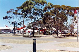
 Missile Park, RAAF Woomera Heritage Centre | |||||||||
| Coordinates | 31°12′0″S 136°49′21″E / 31.20000°S 136.82250°E | ||||||||
| Population | 132 (SAL 2021)[1][2] | ||||||||
| Established | 1947 (77 years ago) | ||||||||
| Postcode(s) | 5720[3] | ||||||||
| Elevation | 169 m (554 ft) | ||||||||
| Location | 446 km (277 mi) N of Adelaide | ||||||||
| State electorate(s) | Giles | ||||||||
| Federal division(s) | Grey | ||||||||
| |||||||||
| Footnotes | Location[3] | ||||||||
Woomera, unofficially Woomera village, refers to the domestic area of RAAF Base Woomera. Woomera village has always been a Defence-owned and operated facility. The village is located on the traditional lands of the Kokatha people[4] in the Far North region[5] of South Australia, but is on Commonwealth-owned land and within the area designated as the 'Woomera Prohibited Area' (WPA). The village is approximately 446 kilometres (277 mi) north of Adelaide. In common usage, "Woomera" refers to the wider RAAF Woomera Range Complex (WRC), a large Australian Defence Force aerospace and systems testing range (the 'Woomera Test Range' (WTR)) covering an area of approximately 122,000 square kilometres (47,000 sq mi) and is operated by the Royal Australian Air Force.
Woomera 'village' is part of RAAF Base Woomera which, along with the Woomera Test Range (WTR), forms the larger entity known as the Woomera Range Complex (WRC), promulgated by Chief of Air Force (CAF) in June 2014. As at the 2016 census the Woomera Village had a population of 146,[6] and its usual population varies between 150 and 200 people, yet the village can provide accommodation and services for up to 500 people per day. Although the complex is closed to the public, Woomera village, and its four museum elements, is open to the public all year round. The location of the Woomera Village can be described as being in the outback desert area of South Australia. It is approximately 446 kilometres (277 mi) north-west of Adelaide[3] and is in the State region known as the Far North.[5] There are 27 pastoral stations within the Woomera Prohibited Area, which essentially forms the ground space of the Woomera Test Range, and there are currently four major mines (2013) - Challenger, Prominent Hill, Peculiar Knob, and Cairn Hill. There is also a long-established precious gems (mainly opal) field near the Coober Pedy end of the Stuart Highway which cuts through the middle of the Range.
- ^ Australian Bureau of Statistics (28 June 2022). "Woomera (suburb and locality)". Australian Census 2021 QuickStats. Retrieved 28 June 2022.
- ^ Australian Bureau of Statistics (28 June 2022). "Woomera Village (suburb and locality)". Australian Census 2021.
- ^ a b c "Woomera, South Australia". postcodes-australia.com. Archived from the original on 23 November 2015. Retrieved 22 November 2015.
- ^ "Home | Kokatha Aboriginal Corporation | Port Augusta". Kokatha. Archived from the original on 10 May 2021. Retrieved 3 June 2021.
- ^ a b "Far North SA government region" (PDF). The Government of South Australia. Archived (PDF) from the original on 24 September 2015. Retrieved 16 August 2015.
- ^ Australian Bureau of Statistics (27 June 2017). "Woomera (State Suburb)". 2016 Census QuickStats. Retrieved 21 August 2017.
