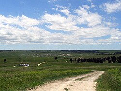
Wounded Knee
Čaŋkpé Opí (Lakota) | |
|---|---|
 Wounded Knee in 2005 | |
| Coordinates: 43°08′37″N 102°22′06″W / 43.14361°N 102.36833°W | |
| Country | |
| State | |
| County | Oglala Lakota |
| Area | |
• Total | 1.07 sq mi (2.77 km2) |
| • Land | 1.07 sq mi (2.77 km2) |
| • Water | 0.00 sq mi (0.00 km2) |
| Elevation | 3,235 ft (986 m) |
| Population | |
• Total | 364 |
| • Density | 340.19/sq mi (131.33/km2) |
| Time zone | UTC-7 (Mountain (MST)) |
| • Summer (DST) | UTC-6 (MDT) |
| ZIP code | 57794 |
| Area code | 605 |
| FIPS code | 46-72900[4] |
| GNIS feature ID | 2393868[2] |
Wounded Knee (Lakota: Čaŋkpé Opí[5]) is a census-designated place (CDP) on the Pine Ridge Indian Reservation in Oglala Lakota County, South Dakota, United States. The population was 364 at the 2020 census.[6]
The town is named for the Wounded Knee Creek which runs through the region.[7] The bones and heart of the Sioux chief Crazy Horse were reputedly buried along this creek by his family following his death in 1877. The town lies within the Pine Ridge Reservation, territory of the Oglala Lakota (Sioux).
- ^ "ArcGIS REST Services Directory". United States Census Bureau. Retrieved October 15, 2022.
- ^ a b U.S. Geological Survey Geographic Names Information System: Wounded Knee
- ^ Cite error: The named reference
USCensusDecennial2020CenPopScriptOnlywas invoked but never defined (see the help page). - ^ "U.S. Census website". United States Census Bureau. Retrieved January 31, 2008.
- ^ Ullrich, Jan F. (2014). New Lakota Dictionary (2nd ed.). Bloomington, IN: Lakota Language Consortium. ISBN 978-0-9761082-9-0.
- ^ "U.S. Census Bureau: Wounded Knee CDP, South Dakota". www.census.gov. United States Census Bureau. Retrieved May 28, 2022.
- ^ Federal Writers' Project (1940). South Dakota place-names, v.1-3. American guide series. University of South Dakota. p. 69.

