Wuda
乌达区 • ᠤᠳᠠ ᠲᠣᠭᠤᠷᠢᠭ Ud | |
|---|---|
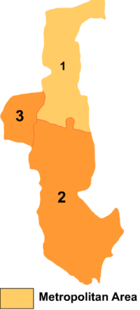
 Wuda is the division labeled '3' on this map of Wuhai City | |
| Coordinates (Wuda District government): 39°30′20″N 106°43′34″E / 39.5056°N 106.7260°E | |
| Country | China |
| Autonomous region | Inner Mongolia |
| Prefecture-level city | Wuhai |
| District seat | Binhai Subdistrict |
| Area | |
• Total | 195.2 km2 (75.4 sq mi) |
| Population (2020)[1] | |
• Total | 122,696 |
| • Density | 630/km2 (1,600/sq mi) |
| Time zone | UTC+8 (China Standard) |
| Website | www |
| Wuda District | |||||||
|---|---|---|---|---|---|---|---|
| Chinese name | |||||||
| Simplified Chinese | 乌达区 | ||||||
| Traditional Chinese | 烏達區 | ||||||
| |||||||
| Mongolian name | |||||||
| Mongolian Cyrillic | Уд тойрог | ||||||
| Mongolian script | ᠤᠳᠠ ᠲᠣᠭᠤᠷᠢᠭ | ||||||
| |||||||
Wuda District or Ud District (Mongolian: ᠤᠳᠠ ᠲᠣᠭᠤᠷᠢᠭ; Chinese: 乌达区) is a district of the city of Wuhai, Inner Mongolia, China, located on the west (left) bank of the Yellow River.

