| Wuntho | |||||||
|---|---|---|---|---|---|---|---|
| Outlying state of the Sagaing Division | |||||||
| Before 1200–2018 | |||||||
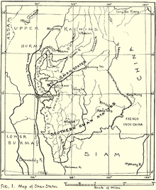
 1917 map of the Burmese Shan States when Wuntho had already been annexed to the British territories | |||||||
| Area | |||||||
• (estimate) | 6,200 km2 (2,400 sq mi) | ||||||
| Population | |||||||
• (estimate) | 150,000 | ||||||
| History | |||||||
• State founded | year-start = 1892 Event start = Katha District Before 1200 | ||||||
• State merged into katha District | 2018 | ||||||
| |||||||

Wuntho (Burmese: ဝန်းသို) or Waing Hso (Shan: ဝဵင်းသိူဝ်) was a native state of Upper Burma when Burma (Myanmar), was under British control. It had an area of around 6,200 square kilometres (2,400 sq mi) with 150,000 inhabitants and lay midway between the Ayeyarwady River and Chindwin Rivers.[1]
- ^ One or more of the preceding sentences incorporates text from a publication now in the public domain: Chisholm, Hugh, ed. (1911). "Wuntho". Encyclopædia Britannica. Vol. 28 (11th ed.). Cambridge University Press. p. 856.