This article needs additional citations for verification. (July 2009) |
| Wyalong New South Wales | |||||||||
|---|---|---|---|---|---|---|---|---|---|
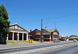
 Neeld St, the main street of Wyalong | |||||||||
| Coordinates | 33°56′S 147°15′E / 33.933°S 147.250°E | ||||||||
| Population | 620 (2021 census)[1] | ||||||||
| Postcode(s) | 2671 | ||||||||
| Elevation | 245 m (804 ft) | ||||||||
| Location |
| ||||||||
| LGA(s) | Bland Shire Council | ||||||||
| State electorate(s) | Cootamundra | ||||||||
| Federal division(s) | Riverina | ||||||||
| |||||||||

Wyalong is part of the Bland Shire located in the Northern Riverina Region of New South Wales, Australia. Established as a gold mining town, it is now a quiet town with historic buildings a few kilometres east of West Wyalong, the major district service centre. At the 2021 census, Wyalong had a population of 620.[1]
- ^ a b Australian Bureau of Statistics (31 October 2012). "Wyalong (State Suburb)". 2011 Census QuickStats. Retrieved 2 April 2015.
