| Wyaston | |
|---|---|
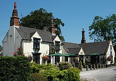
 The Shire Horse, Wyaston | |
Location within Derbyshire | |
| OS grid reference | SK184424 |
| Civil parish | |
| District | |
| Shire county | |
| Region | |
| Country | England |
| Sovereign state | United Kingdom |
| Post town | ASHBOURNE |
| Postcode district | DE6 |
| Police | Derbyshire |
| Fire | Derbyshire |
| Ambulance | East Midlands |
Wyaston is a hamlet in Derbyshire, England.[1] It is located 3 miles south of Ashbourne.
Wyaston is in the civil parish of Edlaston and Wyaston.[2] This is 1⁄4 mile (1⁄2 km) southeast of Edlaston, both have a long history as separate townships, yet they form a single, if dispersed village.[3]
The parish contains some of the highest land locally, the parish peak of 180 metres (590 ft) is by the central road junction in Wyaston.
A community hall is in use at Wyaston village.
- ^ Ordnance Survey: Landranger map sheet 119 Buxton & Matlock (Chesterfield, Bakewell & Dove Dale) (Map). Ordnance Survey. 2012. ISBN 9780319231890.
- ^ "Ordnance Survey Election Maps". www.ordnancesurvey.co.uk. Ordnance Survey. Retrieved 18 February 2016.
- ^ GENUKI. "Genuki: Edlaston and Wyaston, Derbyshire". www.genuki.org.uk. Retrieved 1 September 2021.
