This article needs additional citations for verification. (November 2006) |
Xinye County
新野县 Sinyeh | |
|---|---|
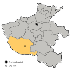
 Xinye in Nanyang | |
 Nanyang in Henan | |
| Coordinates: 32°31′15″N 112°21′36″E / 32.5209°N 112.3601°E | |
| Country | People's Republic of China |
| Province | Henan |
| Prefecture-level city | Nanyang |
| Area | |
• Total | 1,056 km2 (408 sq mi) |
| Population (2020)[2] | |
• Total | 602,827 |
| • Density | 570/km2 (1,500/sq mi) |
| Time zone | UTC+8 (China Standard) |
| Postal code | 473500 |
Xinye (Chinese: 新野; pinyin: Xīnyě; Wade–Giles: Hsin-yeh) is one of the counties of Nanyang[3] that lies in the southwest of Henan province, China. To the south lies the prefecture-level city of Xiangyang in Hubei province, to the east is Tanghe County and to the west is the county-level city of Dengzhou. According to the 2020 Chinese Census, the population of Xinye county is 602,827.[2] Its total area is 1,062 km2 (410 sq mi).
The G55 Erenhot–Guangzhou Expressway runs through Waizi town, which is the northmost town of Xinye. Both Nanyang Jiangying Airport and Xiangyang Liuji Airport are about 60 km (37 mi) away from Xinye.

- ^ 最新人口信息 www.hongheiku.com (in Chinese). hongheiku. Retrieved 2021-01-12.
- ^ a b "中國: 河南省 (地级行政、县级行政区) - 人口统计,图表和地图". www.citypopulation.de. Retrieved 2023-10-08.
- ^ Bernstein, Thomas P.; Xiaobo Lü (2003). Taxation without Representation in Contemporary Rural China. Cambridge University Press. p. 157. ISBN 9781139438049.