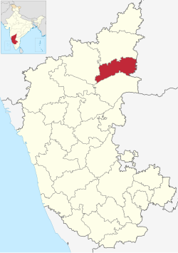
Yadgir district | |
|---|---|
Clockwise from top-left: Taylor Manzil, Chaya Bhagavathi Temple, Basava Sagara, Yadgir town view, Sleeping Buddha Hill | |
| Nicknames: Girinagara, Daal Bowl of state | |
 Location in Karnataka | |
| Coordinates: 16°45′N 77°08′E / 16.75°N 77.13°E | |
| Country | |
| State | Karnataka |
| Formation | 10 April 2010 |
| Founded by | Government of Karnataka |
| Headquarters | Yadgir |
| Talukas | Shahpur, Surpur, Yadgir, Gurmitkal, Hunsgi, Wadgera |
| Government | |
| • Deputy Commissioner & District Magistrate | Susheela B (IAS) |
| Area | |
• Total | 5,234 km2 (2,021 sq mi) |
| Population (2011) | |
• Total | 1,174,271 |
| • Density | 220/km2 (580/sq mi) |
| Languages | |
| • Official | Kannada |
| Time zone | UTC+5:30 (IST) |
| Vehicle registration | KA 33 |
| Website | yadgir |
Yadgir District is one of the 31 districts of Karnataka state in southern India.This district was carved out of Kalaburagi district as the 30th district of Karnataka on 10 April 2010.[1] Yadgir town is the administrative headquarters of the district.[2] The district occupies an area of 5,160.88 km2 (1,992.63 sq mi).
Yadgir district is very rich in cultural traditions. The vast stretch of fertile black soil of the district is known for bumper red gram and jowar crops. The district is the Daal bowl of the state. The district is also known for cluster of cement industries and a distinct stone popularly known as "Malakheda Stone".
Two main rivers, Krishna and Bhima, and a few tributaries flow in this region. The upper Krishna project and Shahapur Taluka in Bendebembali "Core Green Sugar Factory yet to be started. Yadgir which is known the cement, textile, leather, and chemical production in the industrial sectors. The Agriculture College located in Bheemarayana Gudi (B.Gudi).[3]
- ^ "Yadgir becomes State's 30th district". The Hindu. 30 December 2009. Archived from the original on 7 November 2012.
- ^ Sivanandan, T. V. (30 December 2009). "Yadgir district to become reality today". The Hindu. Archived from the original on 23 August 2011.
- ^ "Yadgir History". Official Website of Yadgir District. Government of Karnataka. Archived from the original on 16 July 2014.


