| Yakima River | |
|---|---|
 State Route 10 winds past the Yakima River near the town of Thorp. | |
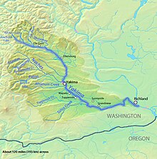
 Map of the Yakima River watershed | |
| Location | |
| Country | United States |
| State | Washington |
| Cities | Cle Elum, Ellensburg, Yakima, Sunnyside, Richland |
| Physical characteristics | |
| Source | Keechelus Lake |
| • location | Kittitas County, Washington |
| • coordinates | 47°19′20″N 121°20′21″W / 47.32222°N 121.33917°W[1] |
| • elevation | 2,520 ft (770 m)[2] |
| Mouth | Columbia River at Lake Wallula |
• location | Richland, Benton County, Washington |
• coordinates | 46°15′10″N 119°13′51″W / 46.25278°N 119.23083°W[1] |
• elevation | 344 ft (105 m)[3] |
| Length | 214 mi (344 km)[4] |
| Basin size | 6,150 sq mi (15,900 km2)[4] |
| Discharge | |
| • location | Kiona, RM 30[5] |
| • average | 3,493 cu ft/s (98.9 m3/s)[5] |
| • minimum | 225 cu ft/s (6.4 m3/s) |
| • maximum | 59,400 cu ft/s (1,680 m3/s) |
| Discharge | |
| • location | Mabton, RM 60 |
| • average | 3,311 cu ft/s (93.8 m3/s) |
| Discharge | |
| • location | Union Gap, RM 107 |
| • average | 3,542 cu ft/s (100.3 m3/s) |
| Discharge | |
| • location | Umtanum, RM 140 |
| • average | 2,430 cu ft/s (69 m3/s) |
| Basin features | |
| Tributaries | |
| • left | Cle Elum River, Teanaway River |
| • right | Naches River |
The Yakima River is a tributary of the Columbia River in south central and eastern Washington state, named for the indigenous Yakama people. Lewis and Clark mention in their journals that the Chin-nâm pam (or the Lower Snake River Chamnapam Nation) called the river Tâpe têtt[6] (also rendered Tapteete),[7] possibly from the French tape-tête, meaning "head hit". The length of the river from headwaters to mouth is 214 miles (344 km), with an average drop of 9.85 feet per mile (1.866 m/km). It is the longest river entirely in Washington state.
- ^ a b U.S. Geological Survey Geographic Names Information System: Yakima River, USGS GNIS.
- ^ Google Earth elevation for GNIS source coordinates.
- ^ Google Earth elevation for GNIS mouth coordinates.
- ^ a b Yakima Subbasin Plan Overview, Northwest Power and Conservation Council
- ^ a b Yakima River and Esquatzel Coulee Basins and the Columbia River from Richland to Kennewick, Water Resources Data-Washington Water Year 2005
- ^ Clark, William (October 18, 1805). "October 18, 1805". Journals of the Lewis & Clark Expedition. Center for Digital Research in the Humanities with the University of Nebraska Press. Retrieved December 24, 2022.
- ^ "Search results for Place : Yakima (Tapteete) River". Journals of the Lewis & Clark Expedition. Center for Digital Research in the Humanities with the University of Nebraska Press. Retrieved December 24, 2022.