Native name: Japanese: 屋久島 | |
|---|---|
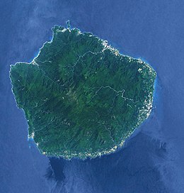
 Landsat image of Yakushima | |
| Geography | |
| Location | East China Sea |
| Coordinates | 30°20′38″N 130°31′26″E / 30.34389°N 130.52389°E |
| Archipelago | Ryukyu Islands |
| Area | 504.88 km2 (194.94 sq mi) |
| Highest elevation | 1,936 m (6352 ft) |
| Highest point | Mount Miyanoura |
| Administration | |
| Kagoshima Prefecture | |
| Demographics | |
| Population | 11,698 (2022) |
| Pop. density | 26.1/km2 (67.6/sq mi) |
| Ethnic groups | Japanese |
| Criteria | Natural: vii, ix |
| Reference | 662 |
| Inscription | 1993 (17th Session) |
| Area | 10,747 ha |
| Official name | Yakushima Nagata-hama |
| Designated | 8 November 2005 |
| Reference no. | 1559[1] |
Yakushima (屋久島) is one of the Ōsumi Islands in Kagoshima Prefecture, Japan. The island, 504.88 km2 (194.94 sq mi) in area, has a population of 13,178. Access to the island is by hydrofoil ferry (7 or 8 times a day from Kagoshima, depending on the season), slow car ferry (once or twice a day from Kagoshima), or by air to Yakushima Airport (3 to 5 times daily from Kagoshima, once daily from Fukuoka and once daily from Osaka). Administratively, the whole island is the town of Yakushima. The town also serves neighbouring Kuchinoerabujima. 42% of the island is within the borders of the Yakushima National Park.[2]
Yakushima's electricity is more than 50% hydroelectric, and surplus power has been used to produce hydrogen gas in an experiment by Kagoshima University. The island has been a test site for Honda's hydrogen fuel cell vehicle research. Hydrogen cars are not stationed on the island, but rather electric cars are run by the municipality.
- ^ "Yakushima Nagata-hama". Ramsar Sites Information Service. Retrieved 25 April 2018.
- ^ Cite error: The named reference
Parkwas invoked but never defined (see the help page).

