| Yampa River | |
|---|---|
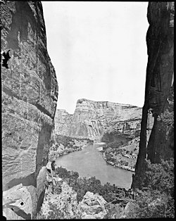
 The Yampa River, c. 1871–1878 | |
 Map of the Yampa River watershed | |
| Location | |
| Country | United States |
| State | Colorado |
| Cities | Steamboat Springs, Craig, Hayden |
| Physical characteristics | |
| Source | Rocky Mountains |
| • coordinates | 40°09′30″N 106°53′59″W / 40.15833°N 106.89972°W[1] |
| • elevation | 7,833 ft (2,387 m)[2] |
| Mouth | Green River |
• location | Dinosaur National Monument |
• coordinates | 40°31′39″N 108°59′04″W / 40.5276°N 108.9845°W[1] |
• elevation | 5,080 ft (1,550 m)[2] |
| Length | 250 mi (400 km)[3] |
| Basin size | 7,660 sq mi (19,800 km2)[4] |
| Discharge | |
| • location | Deerlodge Park[4] |
| • average | 2,069 cu ft/s (58.6 m3/s)[4] |
| • minimum | 1.9 cu ft/s (0.054 m3/s) |
| • maximum | 33,200 cu ft/s (940 m3/s) |
| Basin features | |
| Tributaries | |
| • left | Bear River, Williams Fork |
| • right | Elk River, Little Snake River |
The Yampa River flows 250 miles (400 km) through northwestern Colorado, United States. Rising in the Rocky Mountains, it is a tributary of the Green River and a major part of the Colorado River system. The Yampa is one of the few free-flowing rivers in the western United States, with only a few small dams and diversions.
The name is derived from the Snake Indians word for the Perideridia plant, which has an edible root. John C. Frémont was among the first to record the name 'Yampah' in entries of his journal from 1843, as he found the plant was particularly abundant in the watershed.
- ^ a b U.S. Geological Survey Geographic Names Information System: Yampa River, USGS GNIS.
- ^ a b Google Earth elevation for GNIS coordinates.
- ^ Yampa River, The Columbia Gazetteer of North America. 2000.
- ^ a b c Water Data Report, Colorado 2003, from Water Resources Data Colorado Water Year 2003, USGS.