| Yaquina River | |
|---|---|
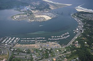
 Yaquina Bay, where the Yaquina River meets the Pacific Ocean | |
| Location | |
| Country | United States |
| State | Oregon |
| County | Benton and Lincoln |
| Physical characteristics | |
| Source | |
| • location | near Summit, Benton County, Central Oregon Coast Range |
| • coordinates | 44°44′57″N 123°36′06″W / 44.74917°N 123.60167°W[1] |
| Mouth | Yaquina Bay |
• location | Newport, Lincoln County |
• coordinates | 44°36′44″N 124°01′04″W / 44.61222°N 124.01778°W[1] |
• elevation | 3 ft (0.91 m)[1] |
| Length | 59 mi (95 km)[2] |
| Basin size | 252 sq mi (650 km2)[2] |
| Discharge | |
| • average | 248 cu ft/s (7.0 m3/s)[2] |
The Yaquina River (/jəˈkwɪnə/ yə-KWIN-ə) is a stream, 59 miles (95 km) long, on the Pacific coast of the U.S. state of Oregon.[2] It drains an area of the Central Oregon Coast Range west of the Willamette Valley near Newport.[3]
It rises in the mountains west of Corvallis along the county line between Benton and Lincoln counties.[3] It flows south, then generally west, in a highly serpentine course, past Eddyville, Chitwood, Toledo, and Elk City, and enters the Pacific in Yaquina Bay, a broad estuary at Newport.[3] When sea level was lower than today, the Yaquina River reached to Stonewall Bank, which is split by a rocky channel.[4]
U.S. Route 20, the Corvallis–Newport highway, follows the river from Eddyville, at the confluence of the river with Little Elk Creek, to slightly downstream of Chitwood.[3] Near the mouth of Yaquina Bay, the river passes under Yaquina Bay Bridge, which carries U.S. Route 101.[5] Other bridges over the river include the Chitwood Covered Bridge at Chitwood.[6]
The National Oceanic and Atmospheric Administration's Pacific Marine Center and the Hatfield Marine Science Center are both along Yaquina Bay.[7][8] Adjacent to the Hatfield Center is the Oregon Coast Aquarium.[9] The Yaquina Bay Lighthouse, contained within the Yaquina Bay State Recreation Site, is on the coast near the mouth of the river.[10]
- ^ a b c "Yaquina River". Geographic Names Information System. United States Geological Survey. November 28, 1980. Retrieved November 16, 2014.
- ^ a b c d Palmer, Tim (2014). Field Guide to Oregon Rivers. Corvallis: Oregon State University Press. pp. 93–94. ISBN 978-0-87071-627-0.
- ^ a b c d Oregon Road and Recreation Atlas (5th ed.). Santa Barbara, California: Benchmark Maps. 2012. pp. 58–59. ISBN 978-0-929591-62-9.
- ^ Yeats, Robert S. "Living with Earthquakes in the Pacific Northwest". Retrieved 2020-12-22.
- ^ Sheehan, Madelynne Diness (2005). Fishing in Oregon. Scappoose, Oregon: Flying Pencil Publications. pp. 53–55. ISBN 0-916473-15-5.
- ^ "Yaquina River (Chitwood) Covered Bridge" (PDF). Oregon Department of Transportation. Retrieved November 18, 2014.
- ^ "About the NOAA Marine Operations Center-Pacific". National Oceanic and Atmospheric Administration. 2012. Retrieved November 16, 2014.
- ^ "Oregon State University Hatfield Marine Science Center: Strategic Plan" (PDF). Oregon State University. 2006. Retrieved November 16, 2014.
- ^ "Visitors Call Aquarium a Great Catch for Coast". The Register-Guard. Eugene, Oregon: Guard Publishing. Associated Press. May 24, 1992. p. 1A. Retrieved November 18, 2014.
- ^ "Yaquina Bay State Recreation Site". Oregon State Parks and Recreation Department. 2014. Retrieved November 18, 2014.
