This article contains too many or overly lengthy quotations. (May 2021) |
Yarkant County
Yarkand; Shache; Soche | |
|---|---|
 A street in Yarkant | |
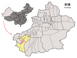
 Yarkant County (red) within Kashgar Prefecture (yellow) and Xinjiang | |
| Coordinates (County government): 38°23′27″N 77°13′24″E / 38.3909°N 77.2232°E | |
| Country | China |
| Autonomous region | Xinjiang |
| Prefecture | Kashgar |
| County seat | Yakan |
| Area | |
| • Total | 8,969 km2 (3,463 sq mi) |
| Elevation | 1,232 m (4,042 ft) |
| Population (2020)[1] | |
| • Total | 860,800 |
| • Density | 96/km2 (250/sq mi) |
| Ethnic groups | |
| • Major ethnic groups | Uyghur[2] |
| Time zone | UTC+8 (China Standard[a]) |
| Postal code | 844700 |
| Website | www |
| Yarkant (Shache) County | |||||||||||
|---|---|---|---|---|---|---|---|---|---|---|---|
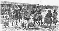
 Street scene in Yarkand in the 1870s | |||||||||||
| Uyghur name | |||||||||||
| Uyghur | يەكەن (ياركەنت) ناھىيىسى | ||||||||||
| Literal meaning | Cliff city[3] | ||||||||||
| |||||||||||
| Chinese name | |||||||||||
| Simplified Chinese | 莎车县 | ||||||||||
| Traditional Chinese | 莎車縣 | ||||||||||
| |||||||||||
| Alternative Chinese name | |||||||||||
| Simplified Chinese | 叶尔羌县 | ||||||||||
| Traditional Chinese | 葉爾羌縣 | ||||||||||
| |||||||||||
Yarkant County,[4][5][6] also Shache County,[7] also transliterated from Uyghur as Yakan County, is a county in the Xinjiang Uyghur Autonomous Region, China, located on the southern rim of the Taklamakan Desert in the Tarim Basin. It is one of 11 counties administered under Kashgar Prefecture. The county, usually referred to as Yarkand[8] in English, was the seat of an ancient Buddhist kingdom on the southern branch of the Silk Road and the Yarkand Khanate. The county sits at an altitude of 1,189 metres (3,901 ft) and as of 2003[update] had a population of 373,492.
The fertile oasis is fed by the Yarkand River, which flows north down from the Karakorum mountains and passes through the Kunlun Mountains, known historically as the Congling mountains (lit. 'Onion Mountains' - from the abundance of wild onions found there). The oasis now covers 3,210 square kilometres (1,240 sq mi), but was likely far more extensive before a period of desiccation affected the region from the 3rd century CE onwards.
Today, Yarkant is a predominantly Uyghur settlement. The irrigated oasis farmland produces cotton, wheat, corn, fruits (especially pomegranates, pears and apricots) and walnuts. Yak and sheep graze in the highlands. Mineral deposits include petroleum, natural gas, gold, copper, lead, bauxite, granite and coal.

- ^ Xinjiang: Prefectures, Cities, Districts and Counties
- ^ 1997年莎车县行政区划. XZQH.org. 19 November 2010. Retrieved 27 February 2020.
面积12平方千米,人口3.8万,其中维吾尔族占93.2%,
- ^ P. Lurje, "Yārkand", Encyclopædia Iranica, online edition
- ^ Andrew Jacobs (29 July 2014). "China's Account of Bloodshed in Far West Is Disputed". New York Times. Retrieved 28 February 2020.
According to Xinhua, it began at a government building in Yarkant County and spread to surrounding streets, where assailants attacked passers-by and set cars on fire.
- ^ An, ed. (20 January 2017). "4.8-magnitude quake jolts Xinjiang: CENC". Xinhua News Agency. Retrieved 28 February 2020.
A 4.8-magnitude earthquake hits Yarkant County of northwest China's Xinjiang Uygur Autonomous Region at 5:54 p.m. Friday (Beijing Time), according to the China Earthquake Networks Center (CENC).
- ^ Yarkant Xian (Variant - V) at GEOnet Names Server, United States National Geospatial-Intelligence Agency
- ^ Shache (Approved - N) at GEOnet Names Server, United States National Geospatial-Intelligence Agency
- ^ Chris Buckly; Steven Lee Myers (18 January 2020). "Battered but Resilient After China's Crackdown". New York Times. Retrieved 7 April 2020.
An ancient Muslim town, Yarkand is a cultural cradle for the Uighurs, who have experienced mass detentions.
Cite error: There are <ref group=lower-alpha> tags or {{efn}} templates on this page, but the references will not show without a {{reflist|group=lower-alpha}} template or {{notelist}} template (see the help page).

