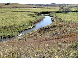
| Yarrowitch River | |
|---|---|
 Yarrowitch River near the Oxley Highway | |
 | |
| Location | |
| Country | Australia |
| State | New South Wales |
| Region | New England Tablelands (IBRA), Northern Tablelands |
| Local government area | Walcha |
| Physical characteristics | |
| Source | Great Dividing Range |
| • location | near Yarrowitch |
| • elevation | 1,100 m (3,600 ft) |
| Mouth | confluence with the Apsley River |
• location | near Tia |
• elevation | 283 m (928 ft) |
| Length | 62 km (39 mi) |
| Basin features | |
| River system | Macleay River catchment |
| Tributaries | |
| • right | Warnes River |
| National parks | Mummel Gulf NP, Oxley Wild Rivers NP |
| [1] | |
Yarrowitch River, a perennial stream of the Macleay River catchment, is located in the Northern Tablelands district of New South Wales, Australia.
- ^ "Map of Yarrowitch River, NSW". Bonzle Digital Atlas of Australia. Retrieved 5 March 2013.