Yazoo County | |
|---|---|
 Postcard. Ricks Memorial Library in Yazoo City. | |
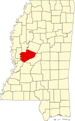
 Location within the U.S. state of Mississippi | |
 Mississippi's location within the U.S. | |
| Coordinates: 32°47′N 90°24′W / 32.78°N 90.4°W | |
| Country | |
| State | |
| Founded | January 21, 1823 |
| Named for | Yazoo River |
| Seat | Yazoo City |
| Largest city | Yazoo City |
| Area | |
| • Total | 934 sq mi (2,420 km2) |
| • Land | 923 sq mi (2,390 km2) |
| • Water | 11 sq mi (30 km2) 1.2% |
| Population (2020) | |
| • Total | 26,743 |
| • Density | 29/sq mi (11/km2) |
| Time zone | UTC−6 (Central) |
| • Summer (DST) | UTC−5 (CDT) |
| ZIP Codes | 39039, 39040, 39088, 39095, 39146, 39162, 39179, 39194 |
| Area code | 662 |
| Congressional district | 2nd |
| Website | yazoocounty |
Yazoo County is a county located in the U.S. state of Mississippi. As of the 2020 census, the population was 26,743.[1] The county seat is Yazoo City.[2] It is named for the Yazoo River, which forms its western border. Its name is said to come from a Choctaw language word meaning "River of Death".[3][4]
- ^ "Census - Geography Profile: Yazoo County, Mississippi". United States Census Bureau. Retrieved January 15, 2023.
- ^ "Find a County". National Association of Counties. Retrieved June 7, 2011.
- ^ Seale, Lea Leslie (1939). Indian Place-Names in Mississippi (Thesis). Louisiana State University. p. 211. Retrieved November 28, 2018.
- ^ Johnson's (revised) Universal Cyclopaedia. 1886.