| Yellow River | |
|---|---|
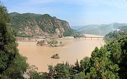
 The Yellow River in Sanmenxia, Henan | |
 Map of the Yellow River, whose watershed covers much of northern China | |
| Native name | |
| Location | |
| Country | China |
| Province | Qinghai, Sichuan, Gansu, Ningxia, Inner Mongolia, Shaanxi, Shanxi, Henan, Shandong |
| Physical characteristics | |
| Source | Bayan Har Mountains |
| • location | Yushu Prefecture, Qinghai |
| • coordinates | 34°29′31″N 96°20′25″E / 34.49194°N 96.34028°E |
| • elevation | 4,800 m (15,700 ft) |
| Mouth | Bohai Sea |
• location | Kenli District, Dongying, Shandong |
• coordinates | 37°45′47″N 119°09′43″E / 37.763°N 119.162°E |
• elevation | 0 m (0 ft) |
| Length | 5,464 km (3,395 mi) |
| Basin size | 752,546 km2 (290,560 sq mi) |
| Discharge | |
| • average | 2,571 m3/s (90,800 cu ft/s) |
| • minimum | 1,030 m3/s (36,000 cu ft/s) |
| • maximum | 58,000 m3/s (2,000,000 cu ft/s) |
| Basin features | |
| Tributaries | |
| • left | Fen River |
| • right | Tao River, Wei River |
 | |
| Yellow River | |||||||||||||||||||||||||||
|---|---|---|---|---|---|---|---|---|---|---|---|---|---|---|---|---|---|---|---|---|---|---|---|---|---|---|---|
| Traditional Chinese | 黃河 | ||||||||||||||||||||||||||
| Simplified Chinese | 黄河 | ||||||||||||||||||||||||||
| |||||||||||||||||||||||||||
The Yellow River[a] is the second-longest river in China and the sixth-longest river system on Earth, with an estimated length of 5,464 km (3,395 mi) and a watershed of 795,000 km2 (307,000 sq mi). Beginning in the Bayan Har Mountains, the river flows generally eastwards before entering the 1,500 km (930 mi) long Ordos Loop, which runs northeast at Gansu through the Ordos Plateau and turns east in Inner Mongolia. The river then turns sharply southwards to form the border between Shanxi and Shaanxi, turns eastwards at its confluence with the Wei River, and flows across the North China Plain before emptying into the Bohai Sea. The river is named for the yellow color of its water, which comes from the large amount of sediment discharged into the water as the river flows through the Loess Plateau.[1]
The Yellow River basin was the birthplace of ancient Chinese civilization. According to traditional Chinese historiography, the Xia dynasty originated on its banks around 2100 BC; Sima Qian's Shiji (c. 91 BC) record that the Xia were founded after the tribes around the Yellow River united to combat the frequent floods in the area. The river has provided fertile soil for agriculture, but since then has flooded and changed course frequently, with one estimate counting 1,593 floods in the 2,540 years between 595 BC and 1946 AD.[2] As such, the Yellow River has been considered a blessing and a curse throughout history, and has been nicknamed both "China's Pride" and "China's Sorrow".[3]
The Yellow River's basin presently has a population of 120 million people, while over 420 million people live in the immediate provinces which rely on it as a water source.[4] The basin comprises 13 percent of China's cultivated land area.[5] The area receives very uneven rainfall, only 2 percent of China's water runoff[5]—water and sediment flow has decreased five-fold since the 1970s, and until recently, the river frequently did not reach the sea.[6] Since 2003, China has been working on the South–North Water Transfer Project to alleviate the strain on the river's water supply.
Cite error: There are <ref group=lower-alpha> tags or {{efn}} templates on this page, but the references will not show without a {{reflist|group=lower-alpha}} template or {{notelist}} template (see the help page).
- ^ Mostern, Ruth; Horne, Ryan M. (2021). The Yellow River: A Natural and Unnatural History. Yale University Press. p. 58. ISBN 978-0-300-23833-4. JSTOR j.ctv1vbd1d8.
- ^ Cite error: The named reference
Tregwas invoked but never defined (see the help page). - ^ Cheng, Linsun and Brown, Kerry (2009) Berkshire encyclopedia of China, Berkshire, p. 1125 ISBN 978-0-9770159-4-8
- ^ Cardascia, Silvia; Panella, Tom (October 2023). "Achieving Water Security in the Yellow River Basin" (PDF). ADB Briefs. Retrieved 25 August 2024.
- ^ a b Li, Guangyong (October 2022). "People's Republic of China: Yellow River Basin Green Farmland and High-Quality Agriculture Development Project" (PDF). NAREE International Limited (Hong Kong).
- ^ "Yellow River". n-h-i.org. Retrieved 25 August 2024.