| York River | |
|---|---|
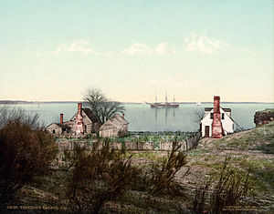
 York River at Yorktown, ca. 1903 | |
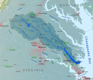
 York River drainage basin | |
| Etymology | York |
| Location | |
| Country | United States |
| State | Virginia |
| Physical characteristics | |
| Source | |
| • location | West Point, Virginia |
| • coordinates | [1] |
| Mouth | |
• location | Chesapeake Bay, Virginia |
| Length | 34 mi (55 km) |
| Discharge | |
| • location | Hanover, Virginia[2] |
| • average | 1,085 cu ft/s (30.7 m3/s)[3] |
The York River is a navigable estuary, approximately 34 miles (55 km) long,[4] in eastern Virginia in the United States. It ranges in width from 1 mile (1.6 km) at its head to 2.5 miles (4.0 km) near its mouth on the west side of Chesapeake Bay. Its watershed drains an area of the coastal plain of Virginia north and east of Richmond.
Its banks were inhabited by indigenous peoples for thousands of years. In 2003 evidence was found of the likely site of Werowocomoco, one of two capitals used by the paramount chief Powhatan before 1609. The site was inhabited since 1200 as a major village. Enormously important in later U.S. history, the river was also the scene of early settlements of the Virginia Colony. It was the site of significant events and battles in both the American Revolutionary War and the American Civil War.
- ^ U.S. Geological Survey Geographic Names Information System: York River
- ^ USGS data Archived 2013-03-21 at the Wayback Machine, accessed 2010-10-29
- ^ USGS data Archived 2013-03-21 at the Wayback Machine, accessed 2010-10-29
- ^ U.S. Geological Survey. National Hydrography Dataset high-resolution flowline data. The National Map Archived 2012-03-29 at the Wayback Machine, accessed April 1, 2011