| Yorkshire Water Way | |
|---|---|
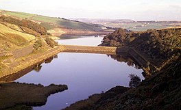
 Bilberry and Digley Reservoirs. The dam wall in the middle is used by as a path by the Yorkshire Water Way | |
| Length | 104 miles (167 km) |
| Location | Yorkshire |
| Established | 2006 |
| Trailheads | Kettlewell, North Yorkshire54°08′48″N 2°02′57″W / 54.1466°N 2.0491°W Langsett Reservoir, South Yorkshire 53°29′52″N 1°40′44″W / 53.4978°N 1.6789°W |
| Use | Hiking |
| Maintained by | Yorkshire Water (partial) |
The Yorkshire Water Way is a 104-mile (167 km) path that runs from Kettlewell in North Yorkshire to Langsett in South Yorkshire. It was devised by Mark Reid in conjunction with Yorkshire Water (YW) and it passes by over more than 20 reservoirs which are operated by Yorkshire Water.