Yoshikawa
吉川市 | |
|---|---|
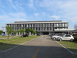
 Yoshikawa City office | |
 Location of Yoshikawa in Saitama Prefecture | |
| Coordinates: 35°53′37.9″N 139°50′29.1″E / 35.893861°N 139.841417°E | |
| Country | |
| Region | Kantō |
| Prefecture | |
| First official recorded | late 5th century (official)[citation needed] |
| Town settled | November 1, 1915 |
| City settled | April 1, 1996 |
| Government | |
| • Mayor | Shigeto Nakahara |
| Area | |
| • Total | 31.7 km2 (12.2 sq mi) |
| Population (February 1, 2021) | |
| • Total | 73,262 |
| • Density | 2,300/km2 (6,000/sq mi) |
| Time zone | UTC+9 (Japan Standard Time) |
| Postal code | 342-8501 |
| Symbols | |
| • Tree | Osmanthus fragrans |
| • Flower | Rhododendron indicum Rhododendron |
| Phone number | 048-982-5111 |
| Address | 1-1 Kiyomino, Yoshikawa-shi, Saitama-ken |
| Website | Official website |
Yoshikawa (吉川市, Yoshikawa-shi) is a city located in Saitama Prefecture, Japan. As of 1 February 2021[update], the city had an estimated population of 73,262 in 31,031 households and a population density of 2300 persons per km2.[1] The total area of the city is 31.66 square kilometres (12.22 sq mi).
- ^ "Yoshikawa city official statistics" (in Japanese). Japan.


