| You Yangs (Wurdi Youang) | |
|---|---|
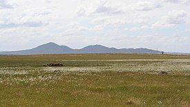
 The You Yangs viewed from the south, with Avalon Airport in the foreground | |
| Highest point | |
| Peak | Flinders Peak |
| Elevation | 319 m (1,047 ft) |
| Dimensions | |
| Length | 24 km (15 mi) |
| Geography | |
| Country | Australia |
| State | Victoria |
| Range coordinates | 37°57′S 144°26′E / 37.950°S 144.433°E |
| Geology | |
| Age of rock | Devonian |
| Type of rock | Igneous, Sedimentary and Metamorphic |
The You Yangs are a series of granite ridges that rise up to 319 m (1,047 ft) above the flat and low-lying Werribee Plain in southern Victoria, Australia, approximately 5 km (3.1 mi) due west of the rural town of Little River, 55 km (34 mi) southwest of Melbourne CBD and 22 km (14 mi) north of Geelong. The main ridge runs roughly north-south for about 9 km (5.6 mi), with a lower extension running for about 15 km (9.3 mi) to the west. Much of the southern parts of the ranges are protected by the You Yangs Regional Park.
The You Yangs sits about halfway between the Brisbane Ranges to the west and the nearest coast of the Corio Bay to the southeast. Although only 319 m at its highest (Flinders Peak, at the southern end), it dominates the surrounding landscape and are clearly identifiable from nearby Geelong, Melbourne and beyond.
The You Yangs are home to a geoglyph of Bunjil, a Dreamtime creator deity to some of the Indigenous people of Victoria, depicted as an wedge-tailed eagle. The geoglyph was constructed by the Australian artist Andrew Rogers in recognition of the local Indigenous Wathaurong people. Unveiled in March 2006, the geoglyph has a wing span of 100 metres and 1500 tonnes of rock was used in its construction.[1][2]