Zeyrek | |
|---|---|
 | |
| Coordinates: 41°1′11″N 28°57′26″E / 41.01972°N 28.95722°E | |
| Country | Turkey |
| Province | Istanbul |
| District | Fatih |
| Population (2022) | 12,863 |
| Time zone | UTC+3 (TRT) |


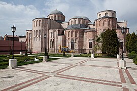
Zeyrek is a neighbourhood in the municipality and district of Fatih, Istanbul Province, Turkey.[1] Its population is 12,863 (2022).[2] It is a picturesque but poor neighbourhood. It takes its name from the huge and prominent Zeyrek Mosque which started life as a Byzantine church and sits on a plateau, overlooking the Golden Horn.[3]
Busy Atatürk Bulvarı runs along the south side of Zeyrek which sits above the Cibali neighbourhood. To its north is the Fatih neighbourhood. Fevzi Paşa Caddesi runs along the western side of Zeyrek.
The centre of Zeyrek forms part of the Historic Areas of Istanbul World Heritage Site. Some of the old wooden houses here were restored in the early 21st century.[4]
The closest tram stop to Zeyrek is Cibali on the T5 tram line. The closest Metro stop is Vezneciler on the M2 line. Many buses lough up and down Atatürk Bulvarı.
- ^ Mahalle, Turkey Civil Administration Departments Inventory. Retrieved 12 July 2023.
- ^ "Address-based population registration system (ADNKS) results dated 31 December 2022, Favorite Reports" (XLS). TÜİK. Retrieved 12 July 2023.
- ^ Eyice (1955), p. 59
- ^ "Zeyrek Evleri restore ediliyor". CNN TÜRK (in Turkish). Retrieved 2022-08-24.

