This article needs additional citations for verification. (June 2011) |
Zhanjiang
湛江市 Chankiang; Tsamkong; Chanchiang | |
|---|---|
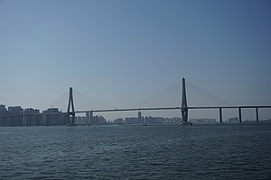
 Zhanjiang Bay Bridge with Chikan's Skyline in the background | |
| Nickname: "Harbor City" (港城) | |
 | |
 Location of Zhanjiang City jurisdiction in Guangdong | |
| Coordinates (Zhanjiang municipal government): 21°16′12″N 110°21′27″E / 21.2701°N 110.3575°E | |
| Country | People's Republic of China |
| Province | Guangdong |
| Municipal seat | Chikan District |
| Government | |
| • CCP Party Chief | Zheng Renhao (郑人豪)[1] |
| • Mayor | Jiang Jianjun (姜建军)[2] |
| Area | |
| 13,225 km2 (5,106 sq mi) | |
| • Urban | 1,720.3 km2 (664.2 sq mi) |
| • Metro | 1,720.3 km2 (664.2 sq mi) |
| Elevation | 21 m (69 ft) |
| Population (2020 census)[3] | |
| 6,981,236 | |
| • Density | 530/km2 (1,400/sq mi) |
| • Urban | 1,931,455 |
| • Urban density | 1,100/km2 (2,900/sq mi) |
| • Metro | 1,931,455 |
| • Metro density | 1,100/km2 (2,900/sq mi) |
| GDP[4] | |
| • Prefecture-level city | CN¥ 356 billion US$ 55.2 billion |
| • Per capita | CN¥ 50,814 US$ 7,876 |
| Time zone | UTC+8 (China Standard) |
| Postal code | 524000 |
| Area code | 759 |
| ISO 3166 code | CN-GD-08 |
| Major Nationalities | Han |
| County-level divisions | 9 |
| License Plate Prefix | 粤G |
| Local dialect | |
| Website | www.zhanjiang.gov.cn |
| Zhanjiang | |||||||||||||||||||||||||||||||
|---|---|---|---|---|---|---|---|---|---|---|---|---|---|---|---|---|---|---|---|---|---|---|---|---|---|---|---|---|---|---|---|
 "Zhanjiang", as written in Chinese | |||||||||||||||||||||||||||||||
| Chinese | 湛江 | ||||||||||||||||||||||||||||||
| Jyutping | zaam3gong1 | ||||||||||||||||||||||||||||||
| Cantonese Yale | Jaamgōng | ||||||||||||||||||||||||||||||
| Hanyu Pinyin | Zhànjiāng | ||||||||||||||||||||||||||||||
| Postal |
| ||||||||||||||||||||||||||||||
| Literal meaning | Azure River | ||||||||||||||||||||||||||||||
| |||||||||||||||||||||||||||||||
Zhanjiang (Chinese: 湛江; pinyin: Zhànjiāng; Jyutping: Zaam3 Gong1; Leizhou Min: Tchiàm-kōng), historically spelled Tsamkong and previously known as Guangzhouwan,[5] is a city in Guangdong province, China. The prefecture-level city of Zhanjiang administers the whole of Leizhou Peninsula, facing Haikou city of Hainan across the Qiongzhou Strait.
As of the 2020 census, its population was 6,981,236 (6,994,832 in 2010) whom 1,931,455 lived in the built-up (or metro) area consisting of four urban districts: Chikan, Xiashan, Potou and Mazhang.[3] In 2007, the city was named China's top ten livable cities by Chinese Cities Brand Value Report, which was released at 2007 Beijing Summit of China Cities Forum.[6]
- ^ "Party Secretary Zheng Renhao". Zhanjiang Municipal Government. Retrieved 8 January 2019.
- ^ "Mayor: Jiang Jianjun". Zhanjiang Municipal Government. Retrieved 8 January 2019.
- ^ a b "China: Guăngdōng (Prefectures, Cities, Districts and Counties) - Population Statistics, Charts and Map".
- ^ 广东省统计局、国家统计局广东调查总队 (August 2016). 《广东统计年鉴-2016》. 中国统计出版社. ISBN 978-7-5037-7837-7. Archived from the original on 22 December 2017.
- ^ Theodore Shabad (1956). China's Changing Map: A Political and Economic Geography of the Chinese People's Republic. New York: Frederick A. Praeger. p. 166. LCCN 55-11530. OCLC 916993074.
With the exception of Shiukwan on the Canton-Hankow railroad, Kwangtung's regional centers are situated along the coast, notably in the Canton delta. There, in addition to Canton, are the cities of Fatshan, Kongmoon and Shekki. The metropolis of western Kwangtung is Tsamkong, and Pakhoi is the chief town of the western panhandle.
- ^ "China's Top 10 Most Livable Cities". hnloudi.gov.cn. Hunan Loudi Official Government. 28 March 2012. Retrieved 4 August 2014.
