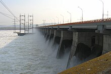
| Zhiguli Dam | |
|---|---|
 | |
| Official name | Жигулёвская ГЭС |
| Location | Zhigulyovsk Russia |
| Coordinates | 53°25′36″N 49°28′44″E / 53.42667°N 49.47889°E |
| Construction began | 1950 |
| Opening date | 1957 |
| Owner(s) | RusHydro |
| Dam and spillways | |
| Type of dam | Embankment dam |
| Impounds | Volga River |
| Height | 52 m (171 ft) |
| Length | 2,800 m (9,200 ft) |
| Width (base) | 750 m (2,460 ft) |
| Spillway capacity | 40,000 m3/s (1,400,000 cu ft/s) |
| Reservoir | |
| Creates | Kuybyshev Reservoir |
| Total capacity | 57.3 km3 (13.7 cu mi) |
| Surface area | 6,450 km2 (2,490 sq mi) |
| Maximum water depth | 41 m (135 ft) |
| Power Station | |
| Turbines | 4 × 120 MW 16 × 125,5 MW |
| Installed capacity | 2,488 MW[1] |
| Annual generation | 11,815[2] GWh |

The Zhiguli Hydroelectric Station or Zhigulyovskaya Hydroelectric Station (Russian: Жигулёвская ГЭС, romanized: Zhigulyovskaya GES), formerly known as Kuybyshev Hydroelectric Station (Kuybyshev GES) is a large dam and hydroelectric station on the Volga River, located near Zhigulyovsk and Tolyatti in Samara Oblast of Russia. It is the sixth stage of the Volga-Kama Cascade of dams, and the second of them by in terms of installed power quantum.
