Zia Pueblo, New Mexico | |
|---|---|
 Zia Pueblo in the late 1800s. | |
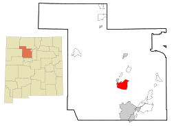
 Location of Zia Pueblo, Sandoval County, New Mexico | |
| Coordinates: 35°30′13″N 106°43′24″W / 35.50361°N 106.72333°W | |
| Country | United States |
| State | New Mexico |
| County | Sandoval |
| Area | |
• Total | 27.08 sq mi (70.12 km2) |
| • Land | 27.03 sq mi (70.01 km2) |
| • Water | 0.04 sq mi (0.12 km2) |
| Elevation | 5,472 ft (1,668 m) |
| Population | |
• Total | 760 |
| • Density | 28.12/sq mi (10.86/km2) |
| Time zone | UTC-7 (Mountain (MST)) |
| • Summer (DST) | UTC-6 (MDT) |
| ZIP code | 87053 |
| Area code | 505 |
| FIPS code | 35-86420 |
| GNIS feature ID | 0928840 |
Zia Pueblo | |
 Zia buffalo dancer | |
| Nearest city | Bernalillo, New Mexico |
| Area | 26 acres (11 ha) |
| Architectural style | Pueblo |
| NRHP reference No. | 73001146[3] |
| NMSRCP No. | 232 |
| Significant dates | |
| Added to NRHP | April 3, 1973 |
| Designated NMSRCP | December 30, 1971 |
Zia Pueblo (Eastern Keres: Tsi'ya, Ts'iiy'a, Spanish: Pueblo de Zía) is a census-designated place (CDP) in Sandoval County, New Mexico, United States. The population was 646 at the 2000 census,[4] with 310 males[4] and 336 females.[4] The pueblo after which the CDP is named is included within the CDP; it is listed on the National Register of Historic Places.[3]
Zia Pueblo is part of the Albuquerque Metropolitan Statistical Area.
- ^ "ArcGIS REST Services Directory". United States Census Bureau. Retrieved October 12, 2022.
- ^ Cite error: The named reference
USCensusDecennial2020CenPopScriptOnlywas invoked but never defined (see the help page). - ^ a b "National Register Information System – (#73001146)". National Register of Historic Places. National Park Service. July 9, 2010.
- ^ a b c "Zia Pueblo CDP, New Mexico". United States Census Bureau. 2000. Archived from the original on February 12, 2020. Retrieved July 5, 2009.

