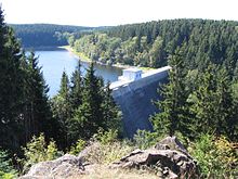
| Zillierbach Dam | |
|---|---|
 | |
| Country | Germany |
| Location | Harz |
| Coordinates | 51°47′21″N 10°46′36″E / 51.78917°N 10.77667°E |
| Construction began | 1934 |
| Opening date | 1936 |
| Dam and spillways | |
| Type of dam | Gravity dam |
| Impounds | Zillierbach |
| Height | 47 m (154 ft) |
| Length | 186 m (610 ft) |
| Width (crest) | 3.5 m (11 ft) |
| Dam volume | 54,000 m3 (1,900,000 cu ft) |
| Reservoir | |
| Total capacity | 2,830,000 m3 (100,000,000 cu ft) |
| Catchment area | 10.7 km2 (4.1 sq mi) |
The Zillierbach Dam (German: Zillierbachtalsperre) lies in the East Harz in the German state of Saxony-Anhalt near the town of Elbingerode (Harz) and impounds the Zillierbach stream. It supplies drinking water to several villages in the High Harz (Elbingerode, Elend (Harz), Schierke, teilweise Rübeland) as well as the town of Wernigerode; it also provides flood protection.
The Zillierbach was known as the Holtemme until the 16th century, then from 1558 as the Zilgerbach. Not until much later was it given its present name. Before the construction of the dam at Peterstein, it supplied the mills in Wernigerode and in the area around Halberstadt. Its variable water supply was evened out by an artificial ditch on the south side of the Hohneklippen, the Wormsgraben, built in the late 12th century.
