Zimmerman | |
|---|---|
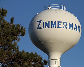
 Zimmerman water tower | |
 Location of the city of Zimmerman within Sherburne County, Minnesota | |
| Coordinates: 45°26′30″N 93°35′53″W / 45.44167°N 93.59806°W | |
| Country | United States |
| State | Minnesota |
| County | Sherburne |
| Incorporated | 1910 |
| Government | |
| • Mayor | Nick Stay |
| Area | |
| • Total | 3.62 sq mi (9.37 km2) |
| • Land | 3.47 sq mi (8.98 km2) |
| • Water | 0.15 sq mi (0.39 km2) |
| Elevation | 991 ft (302 m) |
| Population | |
| • Total | 6,189 |
| • Estimate (2023)[4] | 6,762 |
| • Density | 1,785.63/sq mi (689.43/km2) |
| Time zone | UTC–6 (Central (CST)) |
| • Summer (DST) | UTC–5 (CDT) |
| ZIP Code | 55398 |
| Area code | 763 |
| FIPS code | 27-72238 |
| GNIS feature ID | 2397401[2] |
| Sales tax | 7.375%[5] |
| Website | zimmerman.govoffice.com |
Zimmerman is a city in Sherburne County, Minnesota, United States. The population was 6,189 at the 2020 census.[3]
Zimmerman is a predominantly rural community. U.S. Highway 169 serves as a main route in the area. The community is 42 miles north-northwest of Minneapolis and 33 miles east-southeast of St. Cloud.
- ^ "2020 U.S. Gazetteer Files". United States Census Bureau. Retrieved July 24, 2022.
- ^ a b U.S. Geological Survey Geographic Names Information System: Zimmerman, Minnesota
- ^ a b "Explore Census Data". United States Census Bureau. Retrieved January 11, 2024.
- ^ Cite error: The named reference
USCensusEst2023was invoked but never defined (see the help page). - ^ "Zimmerman (MN) sales tax rate". Retrieved January 11, 2024.