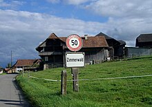
Zimmerwald | |
|---|---|
| Coordinates: 46°53′N 7°28′E / 46.883°N 7.467°E | |
| Country | Switzerland |
| Canton | Bern |
| District | Seftigen |
| Area | |
• Total | 8.94 km2 (3.45 sq mi) |
| Elevation | 840 m (2,760 ft) |
| Population (2002-12) | |
• Total | 870 |
| • Density | 97/km2 (250/sq mi) |
| Time zone | UTC+01:00 (Central European Time) |
| • Summer (DST) | UTC+02:00 (Central European Summer Time) |
| Postal code(s) | 3086 |
| SFOS number | 887 |
| ISO 3166 code | CH-BE |
| Website | |
Zimmerwald (German pronunciation: [ˈtsɪmɐˌvalt]) was an independent municipality in the Canton of Bern, Switzerland until 31 December 2003. It is located on a hill in the proximity of the city of Bern in the Bernese Mittelland. On 1 January 2004 Zimmerwald united with the municipality of Englisberg to form the new municipality of Wald.
On 31 December 2002 the population was 870. The coat of arms is three fir trees on three green mountain peaks with a background that ranges from silver to green.


