Zusmarshausen
Zusmarshausen | |
|---|---|
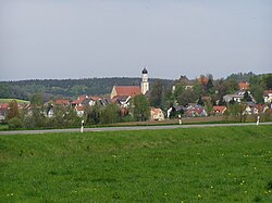
 Zusmarshausen seen from the southwest | |
Location of Zusmarshausen within Augsburg district  | |
| Coordinates: 48°23′N 10°35′E / 48.383°N 10.583°E | |
| Country | Germany |
| State | Bavaria |
| Admin. region | Schwaben |
| District | Augsburg |
| Subdivisions | 8 Ortsteile |
| Government | |
| • Mayor (2020–26) | Bernhard Uhl[1] (CSU) |
| Area | |
• Total | 68.72 km2 (26.53 sq mi) |
| Elevation | 466 m (1,529 ft) |
| Population (2023-12-31)[2] | |
• Total | 6,620 |
| • Density | 96/km2 (250/sq mi) |
| Time zone | UTC+01:00 (CET) |
| • Summer (DST) | UTC+02:00 (CEST) |
| Postal codes | 86441 |
| Dialling codes | +49 (0)8291 |
| Vehicle registration | A |
| Website | www |
Zusmarshausen is a municipality in the district of Augsburg, Bavaria, Germany. The 1648 Battle of Zusmarshausen took place here.
It lies on the river Zusam and is a part of the Augsburg Western Woods Nature Park. Its districts are Friedensdorf, Gabelbach, Gabelbachergreut, Steinekirch, Streitheim, Vallried, Wollbach, Wörleschwang and Zusmarshausen itself.[3]
- ^ Liste der ersten Bürgermeister/Oberbürgermeister in kreisangehörigen Gemeinden, Bayerisches Landesamt für Statistik, 15 July 2021.
- ^ Genesis Online-Datenbank des Bayerischen Landesamtes für Statistik Tabelle 12411-003r Fortschreibung des Bevölkerungsstandes: Gemeinden, Stichtag (Einwohnerzahlen auf Grundlage des Zensus 2011).
- ^ "Markt Zusmarshausen" (in German). Markt Zusmarshausen. Click at "Zusmarshausen und seine Ortsteile". Retrieved 14 October 2018.


